The use of the Georadar technique (noninvasive method) becomes increasingly important in research and mapping of complex networks as well of the individual sub-basement. The ability to perform a “scan” of the subsurface in a quick, noninvasive and inexpensive way ( in comparison to other methods of direct investigation ) appears to be more and more appreciated by the operators and users of local networks underground.
The principle that governs a GPR analysis is based on the emission of an electromagnetic pulse by a transmitting antenna. Usually in the same body antenna is positioned the receiver of the reflected signal. The transmission and reception system perform a continuous modulation a regular frequency . The electromagnetic waves propagate in the subsoil and travel deeply until they meet the target sought. The identification of the target occurs at the surface by receiving the reflected signal from the target itself. Currently on the market there are different configurations for a GPR. The most widely used system is directly mounted on a trolley and is easily transportable.The antenna, transmitter and receiver, are connected to the main body of the instrument through a shielded cable.
The GPR is managed by a central console that controls all stages: from the issue of the waves to the registration of the data file.
The frequency of the spectrum emitted by the device is very wide. The type of transducer used and the length of the pulse sent as well as the amplitude of the sampling time (defined by the operator) create an investigation depth more or less consistent. The analysis will therefore depend on the type of soil investigated (lithology), the size of the sub-service to identify and its depth. Normally for the search and location of underground networks using antennas with center frequencies ranging from 100 to 600 MHz. There are at least two different operating.
Applicazioni:
- Search for services and products: the geo-radar employs an array of sensors and multipolar (200 and 600 MHz antennas), which allows the acquisition of useful information concerning the presence of obstacles (pipes, marine archaeological artifacts and shipwrecks, rocks, etc.) for traditional excavation activities, mini-trench or perforation.
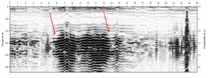
- Stratigraphic profiles analysis and characterization of the soil. The ground penetrating radar is also able to obtain indications on the lithological characteristics of the field to be traversed, in order to establish the method of drilling and optimal shutter speed.
- Determine the location and geometry of underground karst forms, investigate in areas affected by hydrogeological, evaluate changes in geological layers, fractures and thicknesses of land carry, and to identify various types of discontinuities (i.e. geological faults)
- Civil and Environmental Engineering: with a georadar properly set up you can make structural analysis on walls and soil without damaging in any way the artifact, locate rebar in concrete structures, carry out an analysis of the different stratigraphic levels constituting the profile of the asphalt
- Search for environmental remediation: Another interesting application concerns the search and identification of buried structures such as drums, tanks and structures, for possible design and planning of excavation and reconstruction or for the reclamation of areas affected by these presences
- Archaeological Heritage and Cultural: the use of such a modern analysis methodology indirect high-resolution, fast execution and cost, also allows a better understanding of the archaeological heritage still buried (masonry structures, artifacts, burial sites, artifacts , traces of ancient roads) and a more effective planning of excavation, as well as monitoring of works of art and historic buildings.
- Judicial investigations in this case the georadar can be used in the search for weapons, war remnant burial, objects and cavities in walls and floors, locating dead body.