The relief from boat Laser scanner
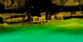
The relief from boat Laser scanner allows to accurately reconstruct the shapes of works completed or under construction, to detect quickly and maritime works hard to reach by land or otherwise not suitable for a terrestrial analysis.
The angle of view at the level of the water surface is in fact the optimal condition to detect the geometry of cliffs, headlands or clays of rivers characterized by a high verticality.
Furthermore, it is possible the simultaneous integration with a multibeam system, in order to have in a single pad the acquisition of data on the surface and below the water level. With this technique you can get geometric relieve and photographic surface structures and appurtenances for the creation of an archive and 3D for the design and placement of new structures (dams, jetties, docks, port yards).
Applications:
- OFFSHORE FACILITIES, PORT AND MARITIME DOMAIN
- MORPHOLOGY COASTS
– Analysis of the coastal
– Monitoring of erosion and sedimentation
– Feasibility studies and design of coastal defenses
- CLAYS OF RIVERS AND LAKES
- REEFS AND CAPES
- INTEGRATION WITH DATA MULTIBEAM
– Simultaneous acquisition of geometry emerged (laser scanner) and submerged (multibeam) in a single system of reference
Terrestrial Laser Scanner Survey
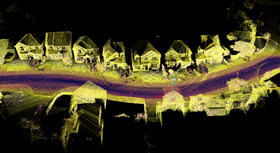
The relief Laser Scan is a technology that is becoming more and more for the relief of complex objects and in particular for the documentation of cultural and environmental heritage. The high quality of the acquired data in a short time, allows you to run the relief geometric objects with a very high level of completeness and detail.
The result is a very numerous set of points distributed on the object to be detected which results in the generation of three-dimensional digital model, georeferenced of the same.
This type of investigation reduce the working times, reducing the cost of the analysis and is able to highlight certain aspects that cannot be achieved with traditional analyzing techniques, such as:
- build / track sections and / or plants of a portion of the excavation area.
- build three-dimensional models of complex structures or articulated.
- sizing areal and volumetric (Cave, mines, tunnels etc.).
- construction of a map database.
- data management platforms for management platforms for any type of design.