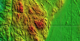
Digital Elevation Model (DEM) obtained from data MBES
Bathymetric analysis performed with two different instrumental methods such as Single Beam Echo Sounder (SBES, single beam echo sounder) and Multy Beams Echo Sounder (MBES, multi beam echo sounder to). The difference between the two systems is given by the resolution of the data searched, the size of the area you want to investigate, in execution speed of the reliefs, from an economic point of view. The SBES represents an economic system in the acquisition of bathymetric data to use in particular areas not very large since they work in a punctiform way, instead allows the MBES The execution of the reliefs in a continuous manner, the emitted beam has an angular opening which goes up to 101 degrees and its field of investigation is generally equal to 2-3 times the depth of the water, this means for example that at a depth of about 100 m, a single sweep of the MBES unable to map from 200-300 m of the seabed (noting also everything that emerges), to derive the bathymetric data with great precision and to achieve accuracy in the mapping of the seabed next to cm. The bathymetric data derived both from the MBES SBES that are processed and their correction is applied tidal appropriately registered or obtained.